|
|
|||||||||
|
|
|||||||||
|
Information from Our Father Lutheran Church's Website: Some distance back from the Mediterranean coast, mountain ranges run along the length of Israel. There is only one important break where a fault in the underlying rock caused a section of the ranges to drop to a height of 300 feet or less. This break, which divides the central highlands from the northern hills of Galilee, is known in Hebrew as the Jezreel Valley, or in its Greek form, Esdraelon ("God will sow," or "May God make fruitful"). Today it is often simply referred to as Ha 'Emeq (the Valley) while the Arabs call it Marj Ibn Amer ("the meadow of the son of Amer"). It is Israel's largest valley and one of its most fertile regions. Sources, however, disagree on its actual name. Some say it is "Jezreel" while others say it is "Esdraelon." Adding to the confusion, some references use the name Plain of Akko or Plain of Megiddo; others say Jezreel indicated only that part of the valley where the city of Jezreel was located; while others hold that Megiddo indicated both the fortified town and the plain on which it was located. For the sake of simplicity, we will use only the name Jezreel Valley.
The geography of Israel made the Jezreel Valley a major travel route from north to south and from east to west. Through the valley ran the main highway linking Egypt with Syria and Mesopotamia, called by the Romans "Via Maris" (Way of the Sea). The importance of the valley in terms of transportation continues to this day, as many trucks from Amman, Jordan travel through it on their way the port of Haifa at the northern tip of Mount Carmel. Although originally the valley floor was marshy, it has always been of great strategic importance, having been rightfully called the "battlefield of Israel." The principal north-south route of the ancient world, called by the Romans Via Maris ("Way of the Sea") cut through the plain on its way from Egypt to Damascus and Mesopotamia. It was an obvious route for trade--and invasion. This accounts for the long list of battles fought there, right up to modern times, from the days of Nebuchadnezzar until the disastrous march of Napoleon Bonaparte from Egypt into Syria. Warriors of every nation under heaven--Jews, Gentiles, Saracens, Crusaders, Frenchmen, Egyptians, Persians, Turks and Arabs--have pitched their tents in the plain. It was the epic battleground where the Israelite Judge, Gideon, with only 300 men, defeated the Midianites and the Amalekites who were "thick as locusts. Their camels could no more be counted than the sand on the seashore." (Judges 7:12). Here, too, Deborah and Barak defeated the Canaanite general Sisera, Saul's army was defeated by the Philistines (1 Samuel 31:1-13), and king Josiah of Judah was slain while battling Pharaoh Neco of Egypt (2 Chronicles 35:19-25). Brutal slaughters for other than political reasons took place in the Jezreel Valley. For example, Naboth owned a vineyard in the town of Jezreel, close to the palace of King Ahab. Ahab wanted to purchase the vineyard for the site of a garden and offered to either pay for it or replace it with another vineyard. But Naboth refused, saying, "The Lord forbid that I should give you the inheritance of my fathers." (1 Kings 21:3). Although Ahab was not pleased, it was his wife Jezebel who was really enraged. She had Naboth stoned to death and then told her husband to go claim what was rightly his. The intersection of the road leading down from the site of Jezreel and connecting to the Afula-Beit She'an road is aptly named Navot Junction (Navot is Hebrew for Naboth). Later, for her part in the killing, Jezebel was thrown from a window by Jehu, Ahab's successor. For many centuries, the plain was a sparsely inhabited swampland owing to poor natural drainage and neglect. After their conquest of Israel in 1517, the sultans declared it Turkish crownland, but by the beginning of the 20th century large areas had passed to absentee Arab landlords. The first Jewish settlement on the plain was Merhavya in 1911. In 1920 the British lifted the land restrictions and large tracts were purchase by Jews for reclamation and settlement. In September 1921 Kibbutz Ein Harod was established near the Spring of Harod--the second Jewish settlement in the area. Since then the swamps have been drained, and dozens of settlements, combining intensive agriculture with light industry, have been set up. Today, the principal urban center is the city of Afula, midway on the valley's east side. The towns, cities and other points of special interest around the Jezreel Valley At the head of the valley, on the west side, is the tel (mound) of Megiddo. This ancient city, dating back before the 3rd millennium BC, was situated at the only pass through the mountain ranges running north-south along the length of Israel. Through this pass ran the aforementioned Via Maris. Because of its strategic location, Megiddo has always been coveted and attacked. It is mentioned repeatedly in the Bible and in the ancient archives of Egypt and Assyria as the scene of conflicts between great empires. By the 1st century AD at least 13 battles had been fought at or near Megiddo [four at Megiddo itself, four at Mount Tabor, one at Mount Gilboa, one at the Hill of Moreh (Endor), one at the city of Jezreel and two at other locations nearby]. Throughout its long history, from about 3300 BC until its mysterious abandonment in the 4th century BC, it knew almost no peace. To quote the introductory video at the visitor center: "Megiddo was built 25 times and destroyed 25 times." It is little wonder that the book of Revelation in the New Testament says that it is where the final battle between the forces of Good and Evil will take place at the end of the world. The word "Armageddon" derives from the Hebrew Har Megiddo, meaning "Mount Megiddo." Spread over a bowl of hills on the northern side of the Jezreel Valley is Nazareth, famous as the site of the announcement ("Annunciation") to Mary of her conception and the childhood of Jesus. The village suffered at the hands of the Romans during the Jewish Revolt of 66-70 AD, then flourished under the Byzantines, and later became an important pilgrimage site for Christians, with many churches attracting large numbers of visitors.
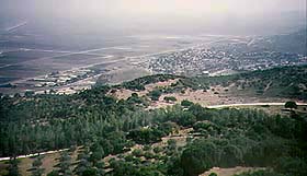
Left: View of the Jezreel Valley from Mount Gilboa Situated in the northeast corner of the valley, about six miles east-southeast of Nazareth and twelve miles west-southwest of the Sea of Galilee, is 1,843 foot-high Mount Tabor. Its isolation and its steep-sided dome shape combine to give it the aura of a sacred mountain, and it has important associations with the judges of Israel and with Christian tradition. It is first mentioned in the Bible as the meeting point of the lands allocated to the tribes of Issachar, Naphtali and Zebulon, and it was here that Barak encamped before his victorious battle with the Canaanite general Sisera. Furthermore, a Christian tradition, dating from the 4th century AD, places Jesus' Transfiguration on Mount Tabor. A long, narrow road now winds along its rocky, oak-covered slopes to Catholic and Orthodox churches commemorating the event. The Kishon River ("winding") is formed by small streams and wadis (mostly dry, seasonal watercourses) on Mount Gilboa to the south and west and the Nazareth hills to the north. The Kishon's headwaters unite in the Jezreel Valley and flow diagonally (from southeast to northwest) some 25 miles, emptying into Haifa Bay just north of Mount Carmel. In Old Testament times the Kishon was the scene of two of the grandest achievements of Israelite history--first, the defeat of the Canaanite general Sisera by Deborah and Barak (Judges 4), and, later, the destruction of the prophets of Baal by Elijah (1 Kings 18:40). Most tourists are disappointed by its appearance, but seasonal rains can swell this normally insignificant brook to a width of 65 feet, thus the reference in Judges 5:21: "the river Kishon swept them away."
|
|||||||||

 The
Jezreel Valley is a roughly triangular plain oriented northwest to
southeast, separating the hilly areas of Galilee to the north from those
of Samaria to the south. Its southwestern side, formed by Mount Carmel, is
about 15 miles long; its north side, formed by the Nazareth Ridge, is
about 12 miles long; and its south side, formed by the Hills of Samaria,
is about 18 miles. From the east side of this triangle three branches
stretch out like the fingers of a hand, separated by two bleak,
ridges--Mount Gilboa and Mount Moreh ("Little Hermon"). The middle
"finger" is more properly called the Harod Valley and it is 11 miles long
and roughly 3 miles wide; it descends from 120 feet above sea-level in the
northwest to 280 feet below sea-level in the southeast and connects the
Jezreel Valley with the Jordan River Valley in the area of Beit She'an
(Beth Shan in the OT; Scythopolis in NT times).
The
Jezreel Valley is a roughly triangular plain oriented northwest to
southeast, separating the hilly areas of Galilee to the north from those
of Samaria to the south. Its southwestern side, formed by Mount Carmel, is
about 15 miles long; its north side, formed by the Nazareth Ridge, is
about 12 miles long; and its south side, formed by the Hills of Samaria,
is about 18 miles. From the east side of this triangle three branches
stretch out like the fingers of a hand, separated by two bleak,
ridges--Mount Gilboa and Mount Moreh ("Little Hermon"). The middle
"finger" is more properly called the Harod Valley and it is 11 miles long
and roughly 3 miles wide; it descends from 120 feet above sea-level in the
northwest to 280 feet below sea-level in the southeast and connects the
Jezreel Valley with the Jordan River Valley in the area of Beit She'an
(Beth Shan in the OT; Scythopolis in NT times). At
the southeastern end of the Jezreel Valley is
At
the southeastern end of the Jezreel Valley is